River to crest at 18.4 feet in FD late evening
Anticipated crest would be 2 feet higher than 1993 flooding
-

-
-Submitted photo
A Fort Dodge Public Works Department dump truck unloads some sand for volunteers assembling sandbags at Amigos, 280 N. First St., Tuesday afternoon.
-
-
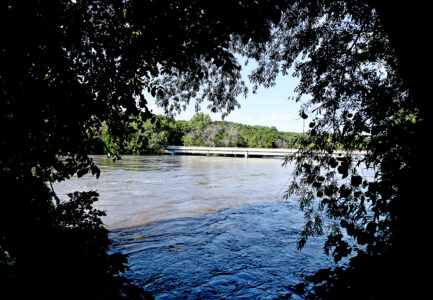
-Messenger photo by Britt Kudla
The high water of the Des Moines River was nearly touching the bottom of the Webster County Road P59 bridge near Kalo Tuesday.
-
-
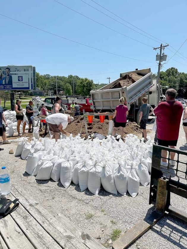
-Submitted photo
Volunteers working near the Otho Community Center tie up newly filled sandbags and stack them up for delivery to places where they will be used to block flood waters.
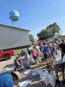
-Submitted photo
A Fort Dodge Public Works Department dump truck unloads some sand for volunteers assembling sandbags at Amigos, 280 N. First St., Tuesday afternoon.
Thousands of sandbags line homes and businesses throughout Webster County as flood waters continue to rise and residents and officials wait for the Des Moines River to crest.
Hundreds of volunteers from throughout central Iowa have spent the week filling and delivering sandbags in hopes of keeping flood waters away from infrastructure. Sandbagging sites were on hold as of Tuesday evening, but residents can still find and bag sand on their own at the Otho Community Center and Willow Ridge Golf Course.
“What an inspiring show of community support,” said Webster County Supervisor Mark Campbell. “The heat has been tough, but it didn’t slow down the willingness of community members to help one another. We feel very good about the preparations that we’ve made in such a short time.”
Many residents are still helping one another. The City of Fort Dodge put out a post on Facebook encouraging those in need to ask for flood preparation help.
“There has been an outpouring of requests for people wanting to help in the preparation efforts,” said Amanda Holmes, communications manager for the City of Fort Dodge. “At this point, we’re encouraging people to visit our social media post specifically created to put residents in need of help with folks who are wanting to chip in.”
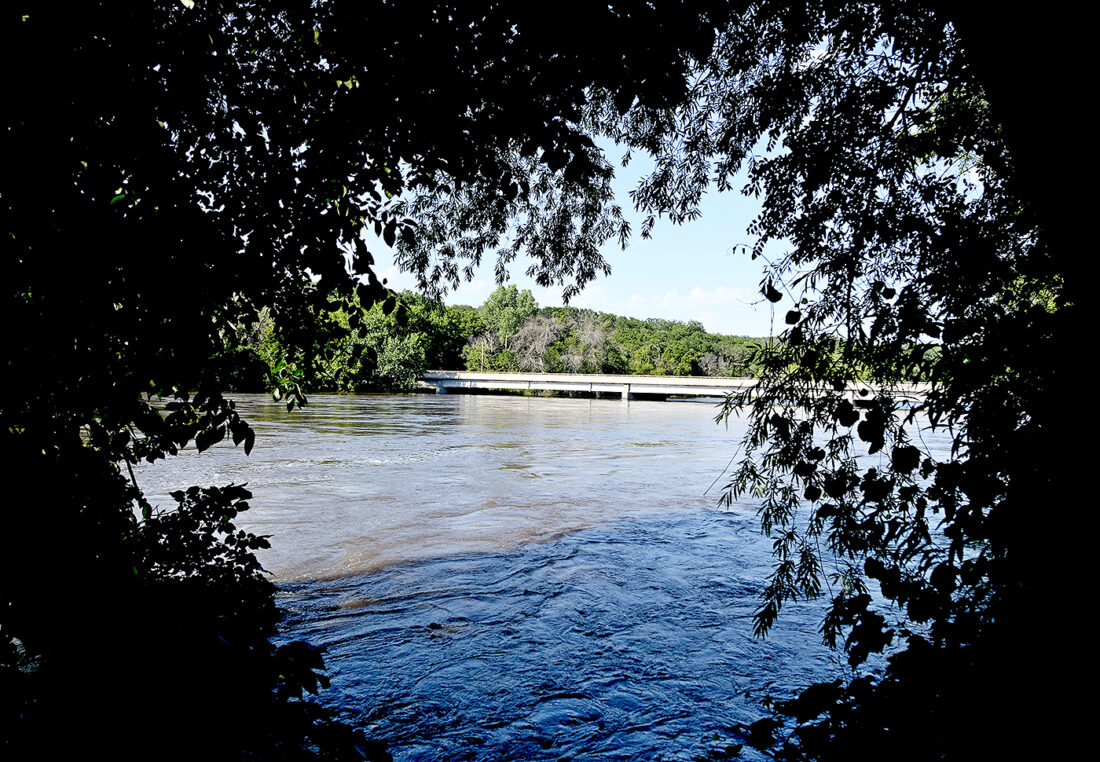
-Messenger photo by Britt Kudla
The high water of the Des Moines River was nearly touching the bottom of the Webster County Road P59 bridge near Kalo Tuesday.
The Des Moines River measured at 15.19 feet on Tuesday afternoon. Updated forecast models predict that level will crest in Fort Dodge at 18.4 feet overnight on Wednesday into Thursday. The crest is expected at Lehigh approximately 12 hours later.
The historic crest of the Des Moines River in 1993 in Fort Dodge was 16.47 feet.
Additional rainfall of potentially 1 to 1.5 inches is also in the forecast for Thursday and Friday. The National Weather Service in Des Moines says this rainfall is not figured into the forecast modeling for the Wednesday evening crest.
Residents in high risk areas throughout Webster County are reminded to prepare their homes and that they may need to evacuate due to flood waters. Multiple roads have also been closed with more closures anticipated.
“Residents who need to evacuate are strongly encouraged to take their medication, medical supplies, and oxygen with them when they evacuate,” said Webster County Emergency Management Coordinator Dylan Hagen. “MidAmerican Energy has also notified citizens in the affected areas that their gas and electricity may be shut off for safety reasons.”

-Submitted photo
Volunteers working near the Otho Community Center tie up newly filled sandbags and stack them up for delivery to places where they will be used to block flood waters.
Temporary housing will be available to residents who have evacuated their homes due to flood waters. To access temporary shelter information, contact Webster County Health Department at 515-573-4107.
Social media rumors on Tuesday also created concern that the Rapidan Dam break in Blue Earth, Minnesota, as well as a levee breach in western Iowa would increase flooding in both Webster and Humboldt counties. However, Jeff Zogg, senior hydrologist with the National Weather Service in Des Moines, said that is not the case as the Blue Earth River and Rapidan Dam drain north into the Mississippi River. The levee breach of the Little Sioux River in Rodney will drain into the Missouri River. Neither are part of the Des Moines River and will not affect local crests.
High Alert Areas
(as of 5 p.m. Tuesday):
• Riverside Drive from U.S. Highway 169 to Humboldt County — ROAD CLOSED
• Breen Addition
• Madison Avenue near 170th Street north of D14 – ROAD CLOSED
• Riverdale Drive – ROAD CLOSED
• Scenic Drive
• First Street Northwest, Fort Dodge – PENDING CLOSURE
• Second Street Northwest, Fort Dodge – PENDING CLOSURE
• Riverside Street – PENDING CLOSURE
• Phinney Park, Fort Dodge
• East Riverside Drive, Fort Dodge – ROAD CLOSED
• Avenue B, Fort Dodge – ROAD CLOSED
• South River Road – ROAD CLOSED
• Riverside Trail – ROAD CLOSED
• Dolliver Memorial State Park – ROAD CLOSED
• River Street, Lehigh
• East Main Street, Lehigh
• Pleasant Street, Lehigh
• Deception Hollow/McGuire Bend Road – ROAD CLOSED
• Xavier Avenue – ROAD CLOSED
• River Road – ROAD CLOSED
• P73/Samson Avenue, Lehigh – ROAD CLOSED
• Meriwether Drive – ROAD CLOSED
• Avenue B – ROAD CLOSED
• Avenue C – ROAD CLOSED
• Skillet Creek Road – ROAD CLOSED
• Skillet Creek Avenue – ROAD CLOSED
Local News
Time for a Second Chance
Fort Dodge’s first Second Chance Job Fair, offering employment opportunities to persons with criminal histories, ...

America at 250: Expansion of a new nation started with trip along the Ohio River
Coal, gypsum were key to growth of Fort Dodge

Living on the road

Ready to take on the world
Man gets 125-year prison sentence for sexual abuse
LIVERMORE — A Humboldt County man has been sentenced to 125 years in prison for sexually abusing three juveniles, ...