Storm spotting class held
-
-
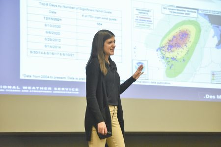
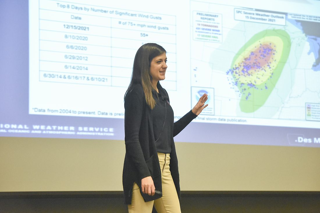
-Messenger photo by Kelby Wingert
Brooke Hagenhoff, a meteorologist with the National Weather Service in Des Moines, leads a storm spotter training at Iowa Central on Thursday evening.
-Messenger photo by Kelby Wingert
Brooke Hagenhoff, a meteorologist with the National Weather Service in Des Moines, leads a storm spotter training at Iowa Central on Thursday evening.
Even with the ever-evolving radar and satellite technology, the National Weather Service still relies on people on the ground to report what they see and observe in order to accurately report and assess storms. They also need those people to know what it is they’re reporting.
The National Weather Service out of Des Moines hosted a storm spotting class at Iowa Central’s Bioscience and Health Sciences Building Thursday night.
The number one priority when storm spotting is safety, according to Brooke Hagenhoff, a meteorologist with the NWS in Des Moines.
“Never go storm spotting at night,” she said, showing a video clip to illustrate how hard it can be to see a tornado after dark.
When storm spotting, spotters should not drive into storms and seek shelter as a storm approaches.
Storm spotting is done at one’s own risk, Hagenhoff said.
Storm spotters can be useful for more than just tracking tornadoes — spotters can report things like cloud types, wind speed, rainfall and hail size.
Hagenhoff gave an overview of some recent storm events, including the 63 tornadoes on March 5, the derecho on Dec. 15, 2021, and the Aug. 10, 2020, derecho.
When a storm system rolls in, it’s important for a spotter to understand the updraft and downdrafts of the storm. An updraft is the first part of the storm where rising air condenses higher up in the atmosphere, and the downdraft is where the precipitation falls out of the storm structure toward the ground.
“Think of it this way, an updraft is when a storm breathes in, and the downdraft is when a storm exhales,” Hagenhoff said.
Using photos and videos of actual storm events across Iowa, Hagenhoff showed the spotters how to identify wall clouds, shelf clouds, funnel clouds and scud clouds.
“Scud clouds are tricky because they happen with your updraft and your downdraft and they don’t do anything bad except trick you into looking like other things,” she said. “They can look like funnel clouds and tornadoes, but they’re not.”
One thing she noted in relation to tornadoes is that not every wall cloud will produce a tornado, but every tornado is produced by a wall cloud.
“The wall cloud is the visual manifestation of the strongest part of a storm,” Hagenhoff said. “When a wall-type rotates, it needs to be watched very carefully.”
Scud clouds are the wispy clouds on the edges of storms that can, on first glance, look like a funnel cloud. However, a funnel cloud is going to have clear vertical rotation and be more defined on the horizon.
“Keep in mind that these are going to be persistent, they won’t come and go really quickly,” Hagenhoff said of funnel clouds. “They’re going to last a long time and have a persistent rotation, at least 10 minutes if not longer.”
Storm spotters can report their observations in a number of ways, including by calling 1-800-SKYWARN, filling out a reporting form on the NWS website and posting on social media and tagging @NWSDesMoines. Hagenhoff encourages spotters to be as specific as possible in their reports, including time, location, flooding information, details on hail size or damage, etc. The NWS also welcomes photos and videos with the reports.
Future storm spotting classes can be found at https://www.weather.gov/dmx/stormspotting.
Local News
Go and Do: April 3, 2026
Around the area CLARION — The Spring Coin Show will be held from 9 a.m. to 4 p.m. SATURDAY at the Heartland ...

Mental exam ordered for McCuddin
Dairy goats a year-round commitment
Bringing the zoo to Friendship Haven
Ag in the Classroom brings Earth Day to life